Soaring over Berlin
Researchers from Freie Universität Berlin go on aerial sensing missions to support the European satellite SENTINEL-5P
Jul 15, 2016
Thomas Ruhtz (second from left) of Freie Universität and Dirk Schüttemeyer (second from right) of the European Space Agency (ESA) work with students to prepare sensors for installation.
Image Credit: Manuel Krane
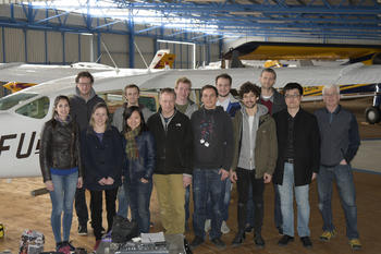
The team headed by Thomas Ruhtz (sixth from left) in front of Freie Universität’s Cessna.
Image Credit: Manuel Krane
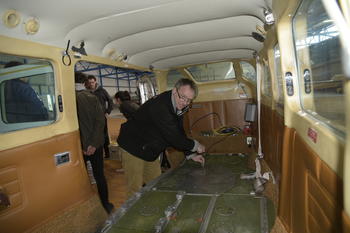
Thomas Ruhtz prepares the research aircraft for the installation of the sensors.
Image Credit: Manuel Krane
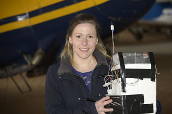
Mirjam den Hoed with the sensor that was built into the research plane.
Image Credit: Manuel Krane
The research aircraft of Freie Universität (front) and the German Aerospace Center (DLR) site in Oberpfaffenhofen (back) before the start of the sensing missions.
Image Credit: Thomas Ruhtz
Mirjam den Hoed stands in the hangar at the airport in Schönhagen, Brandenburg. Den Hoed, a meteorologist, is unpacking a structure made from expanded polystyrene foam that looks like a cross between R2-D2 and a time bomb. However, she is neither a Star Wars fan, nor is she planning a crime.
The device is actually a sensor that can log meteorological data. Den Hoed developed it with researcher colleagues at the Royal Netherlands Meteorological Institute (KNMI) in De Bilt. The sensor, together with other measuring equipment, has been installed in an aircraft belonging to the Institute for Space Sciences at Freie Universität Berlin. Plans call for the plane to be used to measure air pollution in Europe.
As part of an international cooperative research project, the plan is for aircraft to fly special sensing missions to support and verify the results generated by the satellite SENTINEL-5P, which is due to launch in October. SENTINEL-5P was developed by the European Space Agency (ESA) in cooperation with the Netherlands with the goal of monitoring air pollution on the continent. To be able to verify the satellite’s results, aerial sensing missions must be flown to take additional air pollution measurements. The data collected on these missions can then be compared against the satellite’s data later on.
A specially prepared Cessna that is used for research purposes by the Institute for Space Sciences at Freie Universität is to be used to fly these missions. Through a hole in the bottom of the plane, optical sensors are used to measure the change in reflected sunlight after it passes through the atmosphere and the reflection on the ground.
This method can be used to determine aspects such as the level of nitrogen dioxide in the air. To take the measurements, however, a cloudless sky is needed, because clouds can affect the measurements in indeterminate ways otherwise. “We need one or two good days,” says Dirk Schüttemeyer, the coordinator of aerial research campaigns at ESA, which is co-financing the project.
The teams involved in the cooperative international project installed their instruments in the Cessna in April. The University of Bremen’s “AirMap” sensor measures nitrogen oxides; the “Tropolight” sensor is a slimmed-down version of the satellite system, developed by the Netherlands Organisation for Applied Scientific Research (TNO); and the “SWING” sensor was supplied by the Belgian Institute for Space Aeronomy (BIRA). The “FUBISS-ASA2” sun photometer from Freie Universität uses solar radiation to measure haze in the atmosphere.
The sensing missions will be accompanied by an aircraft of the German Aerospace Center (DLR), with the Freie Universität Cessna flying at altitudes of 600 to 3,000 meters and the DLR plane flying at 6,000 meters. These flights are being financed by EUFAR (European Fleet for Airborne Research).
Measurements in Bucharest
Plans originally called for this kind of dual sensing mission to take place in Bucharest last year, but the local authorities were unable to grant flight authorization for the DLR aircraft in time. That was when the idea arose of flying the dual mission in Berlin instead. “We wanted to take the measurements in a large, densely developed city. That works in either Berlin or Bucharest,” explains Schüttemeyer.
Complicated Installation
Den Hoed has now installed her instrument in the plane. With its small size, it was the last device to be put in place. Before that, the metal structure that normally holds smaller measurement instruments had to be removed temporarily to make space for the large “AirMap” sensor to be installed. Hoed is happy. “Now we can use this to measure air pollution with great accuracy,” she says.
The plane flew a short trial mission around the area to test the new instruments on the day of the installation, in mid-April. To obtain usable measurement results, though, the team had to wait for better weather. With this in mind, the researchers from Belgium and the Netherlands briefly returned to Schönhagen to fly the missions. At the same time, groups from the University of Heidelberg and the Max Planck Institute in Mainz also traversed Berlin by car, taking ground measurements.
“All of it worked great. We had excellent weather and were able to collect all of the data we wanted to,” says Thomas Ruhtz, a researcher at the Institute for Space Sciences at Freie Universität, outlining the project’s positive results. Once the measurements have been analyzed, it will become clear to what extent the results yielded by different sensors differ from each other, Schüttemeyer explains. “But it’s not a competition. It’s more like how people feel about the Olympics – the main thing is to be a part of it. Everyone who flew along is eagerly awaiting the chance to see how their measurements stack up against the others.”
After all, he says, the goal of the campaign is to support the SENTINEL-5P satellite when, starting in October, it transmits daily pictures from space. “Based on this, it will then be possible to make better global statements regarding nitrogen dioxide pollution than is currently possible with the few ground measuring stations that exist,” Ruhtz says. Ultimately, these kinds of stations only take stationary measurements, and only at the height where they are themselves located – a couple of meters above the ground. “From the satellite, on the other hand,” the researcher continues, “we can determine reliable values across large areas and, using the plane, for different altitudes as well.”
Further Information
- Thomas Ruhtz, Institute for Space Sciences, Freie Universität, Tel.: +49 30 838-56 662, Email: ruhtz@zedat.fu-berlin.de


